- Home
- Accommodation
- Activities
- Area Info
- Maps
- Photo Galleries
- Real Estate
- Travel
Paquera Coast and Islands Map
The following map shows the Paquera area, including the following important locations to travelers that come to Montezuma and Santa Teresa:
Ferry Landing Spot
Curu Park
Tortuga Islands
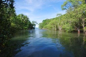
Playa Organos Beach and Mangrove Area

Paquera Area Articles:
- Playa Organos
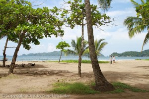 One of the best-kept secrets of the Southern Nicoya Peninsula is Playa Organos, which is a 10-15 minute drive from the ferry terminal between Puntarenas and Paquera. The beach is one of the few of the area that’s authentic and natural, which has its upsides and downsides. The upside of course is that there’s a ...
 - Curú National Wildlife Refuge
 Curú National Wildlife Refuge, known in Costa Rica as “Refugio Nacional de Vida Silvestre Curú” is the best park in the southern Nicoya peninsula. It offers scuba diving, a beautiful white sand beach, tons of wild animals including two reintroduction programs, cabinas for rent, mangrove swamps, hiking trails, and much more. Unfortunately, most tourists zip ...
 - Bahia Rica’s Three Day Sea Kayaking Adventure
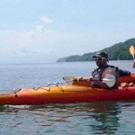 Just around the corner from where the ferry lands in Paquera, you can find Bahia Rica’s lodge. This is a very remote part of Costa Rica and the Southern Nicoya Peninsula, yet it’s easy to get to. From the lodge you can easily walk down to a beach which is nearly private. ...


Great Stuff

Clandestina Restaurant
My new favorite restaurant, Clandestina is not to be missed by food lovers staying anywhere near to Montezuma. Established in March 2015, Clandestina is the new kid on the block. The Oregon/Tico collaboration is a winner among locals and travelers alike, with artisan craft beers, made onsite by Butterfly Brewing Co. and delicious, exciting […]


